
Active sensing and potential use of frequencies around 45 MHz

Andre Tkacenko, Signal Analysis Engineer, Spectrum Engineering Group (332G), Jet Propulsion Laboratory (JPL), National Aeronautics and Space Administration (NASA)
Spaceborne active sensing for the Earth exploration-satellite service (EESS) consists of the following types (see Recommendation ITU–R RS.1166‑4):
- Scatterometers — for measuring wind speed and direction: 5.25–5.57 gigahertz (GHz), 8.55–8.65 GHz, 9.5–9.8 GHz, 13.25–13.75 GHz, 17.2–17.3 GHz, and 35.5–36.0 GHz;
- Altimeters — for estimating altitude over land and ocean surface: 3.1–3.3 GHz, 5.25–5.57 GHz, 8.55–8.65 GHz, 9.5–9.8 GHz, 13.25–13.75 GHz, and 35.5–35.6 GHz;
- Synthetic aperture radar (SAR) imagers — for producing radar images or topographical maps: 432–438 megahertz (MHz), 1215–1300 MHz, 3100–3300 MHz, 5250–5570 MHz, 8550–8650 MHz, and 9200–10400 MHz;
- Precipitation radars — for determining rainfall rate: 13.25–13.75 GHz, 24.05–24.25 GHz, and 35.5–36.0 GHz;
- Cloud profile radars — for ascertaining cloud reflectivity profile: 94.0–94.1 GHz, 133.5–134.0 GHz, and 237.9–238 GHz.
The advent of ground-penetrating radar (GPR) systems has sparked an interest in using such instruments, called sounders, for spaceborne active sensing.
Space agencies, including the US National Aeronautics and Space Administration (NASA) and the European Space Agency (ESA), are interested in using sounders to explore the signatures of climate change on Earth.
The mission concept for the Orbiting Arid Subsurface and Ice Sheet Sounder (OASIS), a joint venture between the NASA Jet Propulsion Laboratory (JPL) and the Qatar Environment and Energy Research Institute (QEERI), involves studying subsurface climate change in areas like polar ice sheets and hyper-arid deserts. Such exploration requires lower frequencies than those from above, typically in the high-frequency (HF) or very high-frequency (VHF) bands. Centre frequencies around 50 MHz are required to meet the mission’s science objectives.
Exploring subsurface signatures of climate change
Concepts like OASIS involve several key scientific objectives.
Ice sheets
- Measure thickness to deduce topography, roughness, and geological time scale of strata;
- Identify and characterize regions of past ice flow reorganization;
- Reassess current state and discharge rates of ice;
- Integrate scientific observations with ice flow models to determine impact on sea-level rise.
Deserts
- Measure depth and spatial distribution of water tables in shallow aquifers on a large scale at high resolution;
- Characterize geologic structures according to recharge, flow, and discharge of groundwater;
- Combine observations with available data to provide insights into evolution of aquifers.
Range of frequencies needed for ground penetration
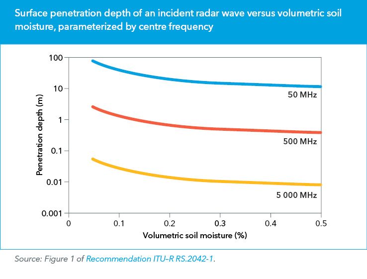
The graph plots surface penetration depth versus volumetric soil moisture. Exploring subsurface ice sheets and shallow aquifers — less than 100 metres deep — requires a centre frequency of around 50 MHz.
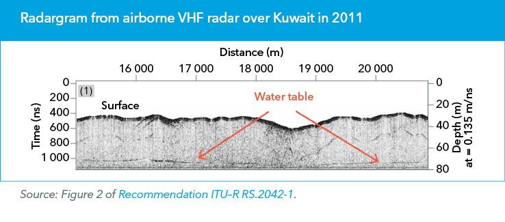
Airborne sounders have made measurements around 50 MHz in desertic areas of the Arabian Peninsula. The figure shows a sample radargram from such a campaign.
For OASIS, the designers considered a 45 MHz centre frequency, 10 MHz bandwidth emission (see Recommendation ITU–R RS.2042‑1).
Several factors went into designing this radar waveform, including:
- Centre frequency: 45 MHz — as low as possible for subsurface penetration without suffering excessive ionospheric delay, dispersion, and loss;
- Spatial resolution: 10 MHz bandwidth — to achieve a vertical resolution of 10 metres in ice and dry sand.
Intended operational usage
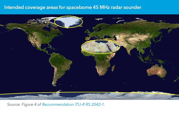
To meet scientific objectives, operations are intended to be implemented over uninhabited or sparsely populated areas, including the ice sheets of Antarctica and Greenland, along with desertic areas of the North African Sahara and Arabian Peninsula.
To provide adequate coverage, spaceborne sounders can typically be expected to operate on satellites in Sun-synchronous orbit (SSO). For OASIS, specifically, a 548‑day exact repeat orbit at an altitude of 400 kilometres altitude was considered. To minimize impact on incumbent services, operations would take place in the early morning via an SSO with a local time of the ascending node (LTAN) of 4 am, within a 10‑minute window in a 92.7‑minute orbit.
Raising possibilities
If the upcoming ITU World Radiocommunication Conference, WRC‑23, were to grant a frequency allocation for EESS (active) at or around 45 MHz, then this would greatly enhance the likelihood of concepts like OASIS coming to fruition.
Download your copy of the ITU News Magazine: Science services.
Header image credit: NASA