How AI can help protect forest ecosystems
By ITU News
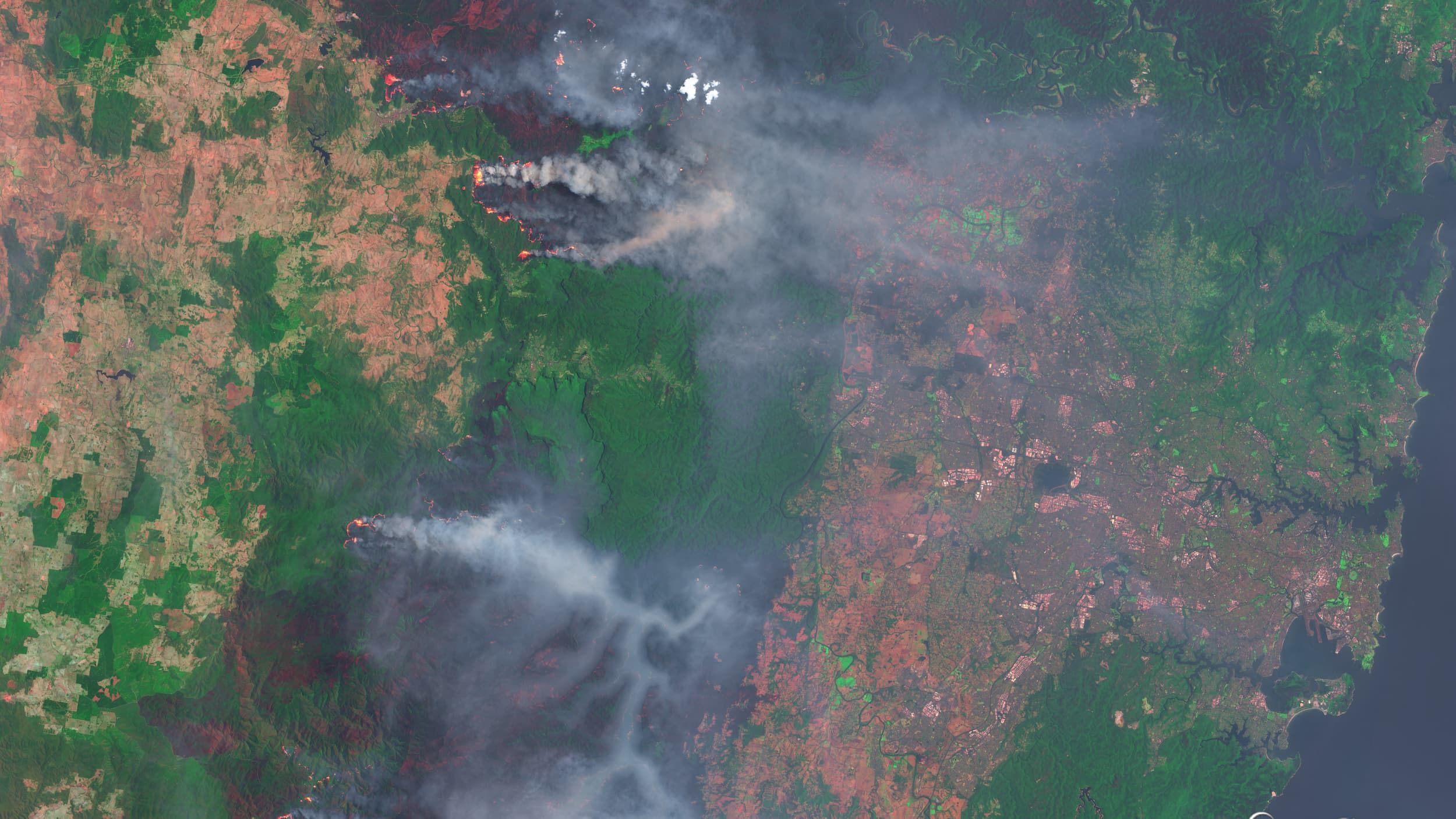
Late 2019 and early 2020 saw a wave of wildfires sweep Australia, devastating local ecosystems.
The fires prompted national science agency CSIRO – the Commonwealth Scientific and Industrial Research Organisation – to update its artificial intelligence (AI) model that aims to predict bushfire speed and behaviour.
The Vesta Mark 2 system, building on lessons from fires over the last four decades, combines this historical data with weather forecasts, forest cover, and other new inputs. Authorities can then anticipate each fire’s evolution to help mitigate damage.
Predictive analytics and machine learning models like Vesta Mark 2 are helping scientists and authorities in different parts of the world in the quest for better forest management. This also includes restoring areas damaged by fires, logging, or clear-cutting.
Land use – including deforestation, which releases heat-absorbing carbon into the atmosphere – accounts for 25 per cent of global greenhouse gas emissions, according to the Intergovernmental Panel on Climate Change (IPCC) Special Report on Climate Change and Land.
Incorporating digital technologies to optimize climate response is a key topic at the United Nations climate conference, COP27, this month.
“It all starts with data”
Reforestation requires accurate information. “It all starts with data,” affirms Inge Jonckheere, forests and climate officer at the UN Food and Agriculture Organization (FAO). “We need to know the situation and monitor it before we can really act.”
Combining satellite imagery with in-situ data is ideal for the most effective and sustainable forest management, according to experts at a recent AI for Good keynote.
“The climate is not on track, so we really need to predict, mitigate and respond to forest disturbances,” Jonckheere added. “We need to know the past in order to predict the future. And for this ML [machine learning] and AI can really help.”
FAO launched Open Foris, a free and open access toolkit for data collection, analysis, and reporting. At least 44 countries have integrated Open Foris into their national forest monitoring systems, while 130 countries have tested it.
The initiative’s Collect Earth Online system lets multiple users aggregate information into a common database for interpreting high-resolution satellite imagery.
Only credible data is useful, and “trust in data can only be instilled if the data is of high quality,” said Punit Santani, who leads the Sustainability Data Hub for insights and data at Capgemini.
The Sustainability Data Hub framework aims to help organizations overcome challenges in applying sustainability analytics, including ease of use and shareability.
The platform’s three “pillars” – data exchange, analytics workbench, and sustainability play – constitute a framework that brings together various assets and analytics across sustainability use cases. This enables users to consolidate data from around the world in one place, combine it to build various AI use cases, and share the outcomes of those use cases globally.
Connecting the dots at scale
Together, AI systems and satellite imagery enable a broader understanding of what is happening the ground.
“AI and satellites give us the scale to be able to apply skill sets that people weren’t applying to climate before,” said Kait Creamer, marketing manager of Overstory, a company specialising in real-time vegetation intelligence. “People start to be able to connect the dots and see what we can do to make a difference.”
Sustainable agriculture and forestry projects, along with other responsible land use initiatives, reduce greenhouse gas emissions. Notably, they can also absorb and store existing carbon dioxide (CO2).
Their overall impact, however, is only clear with integrated, cross-border data linked to climate mitigation goals.
Open Foris tools include the cloud-based SEPAL, a system for Earth observation, data access, processing, and analysis for land monitoring, which is available as a web platform and mobile app.
Early warning systems for action
Even the best field monitoring is useless without mechanisms for action and enforcement. In vast areas like the Amazon rainforest, whose maintenance is vital for planetary well-being, ecosystem protection depends on equipping local communities with early warning systems.
The Forest Watcher app, part of the World Resources Institute’s open-source Global Forest Watch initiative, uses satellite imagery to warn users of imminent risks to their local ecosystem.
Such systems can also bolster environmental law enforcement in countries or regions with limited means to combat deforestation.
Innovative technologies help bring the broad patterns of illicit deforestation into clear focus. Most instances of deliberate deforestation – just like illegal mining and other criminal activities – occur close to the sites of previous offenses.
“In the Amazon we have some hints,” said Stéphane Mermoz, CEO and research scientist at GlobEO, a company that provides services based on Earth observation and remote sensing data. “We know that most of the deforestation occurs close to past deforestation areas, between zero and five kilometres.”
The header image shows a satellite image composite of forest fires west of Sydney, Australia on December 21st, 2019. Contains modified Copernicus Sentinel data from 2019. Credit: Christian Pauschert via Adobe Stock.