| Home : ITU News magazine | |||||||||||||||||||
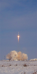
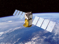
Giove-A blazes a trailGalileo is an initiative of the European Commission and is being developed by the European Space Agency (ESA) as well as the private sector. On 12 January 2006, the first signals came from its pilot element, the Giove-A satellite that was launched into a 23 258-kilometre circular orbit on 28 December 2005. Its name is an acronym for “Galileo in-orbit validation element,” and its primary mission is to establish Galileo’s use of the radio frequencies that were allocated to the system by ITU at the World Radiocommunication Conference in 2000. Giove-A also has the task of testing technologies that will be crucial for operational Galileo satellites, including receivers on the ground, and of investigating the radiation environment of the satellites’ planned orbits. Giove-B, is scheduled to be launched in the first half of 2006 with more test equipment on board, including a passive hydrogen-maser atomic clock that is being built in Switzerland. Eventually, it is planned that 30 satellites will be deployed in the Galileo system, over three planes in medium Earth orbit. A spare satellite will be included in each plane, which controllers will be able to move as a replacement for any that becomes faulty. The system as a whole will offer a global service that is expected to start in 2010.
Why another system?The demand for positioning systems has increased tremendously in recent years and it can be said that new ones are needed to provide the wider array of services that will be offered to a booming market. Another argument in favour of Galileo is that it gives users more than one global system upon which to rely. Continuity of service is an important priority for many users.
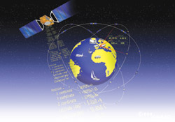
In addition, ESA says that Galileo will offer a highly accurate service. When signals from its two frequency bands are received, the free-of-charge “open service” will locate items to within 4 metres; location to within 1 metre is expected under Galileo’s paid-for “commercial service,” and this could go down as low as 10 centimetres if ground stations complement the satellite signal. In addition, Galileo has enhanced reliability through including a signal “integrity message” that immediately tells the user about any errors. Also, it will be possible to receive Galileo in areas at extreme latitudes. How will it be used?As well as offering an open service and an encrypted commercial one, Galileo will also provide an encrypted safety-of-life service, to be used by emergency personnel, security authorities, air traffic controllers, and so on. This is just one area in which the demand for satellite navigation systems is growing rapidly. Other applications range widely from monitoring the speed of cars, to gathering geographic data, to helping find sailors lost at sea. Consumers are expected to be able to switch back and forth between the Galileo and GPS systems using the same equipment. This will often be a mobile phone, and tracking these devices is likely to be a particularly important use of Galileo. It opens up many possibilities for “location-based services,” such as telling users how to find the nearest station or restaurant. Emergency calls, too, will become easier to handle. The European Union estimates that of the 180 million or so distress calls made every year in Europe, about 6 million have a poorer than required response because of missing information about the caller’s location. Galileo, in conjunction with complementary satellite services and alongside the worldwide boom in mobile communications, should make an important contribution to the spread and improvement of location-based information. |
|||||||||||||||||||